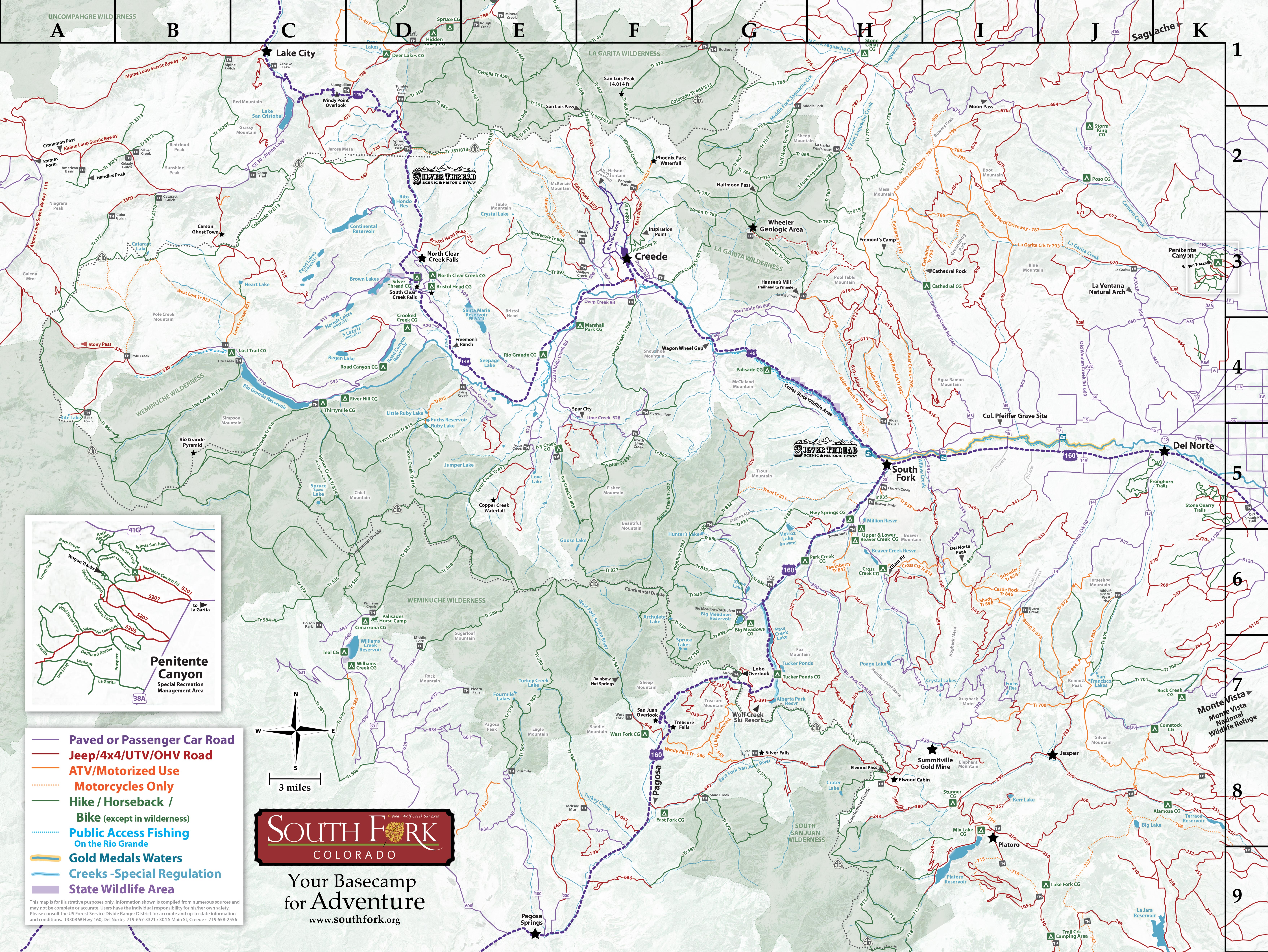
The Rio Grande National Forest is filled with riding opportunities for beginner and advanced riders. Single-track motorized trails can be found within a couple miles drive from town, and some are specifically listed as multi-use for bikes…not to mention the hundreds of miles of forest service access roads open to cyclists of all abilities. Many trails are multi use - so be prepared for hikers, horses, and ATV’s along the way.
Know Before You Go
- Tell Someone: Where you’re going When you’ll be back
- Check the Weather; and then wear ALL the layers anyway
- Altitude WILL effect you, and maybe your bike! You are at 8,000ft+ elevation - we have more beauty, but less oxygen!
- Maps - don’t rely on cell service. Either have them printed or downloaded.
- Stick to the trails; Leave any gates the way you find them!
- Uphill has the right-of-way. Bikers yield to hikers, all yield to horses.
- Buy a Search & Rescue Card ($3 online). The card helps reimburse local SAR team’s expenses for search and rescue missions
Our Favorite Single-Track Motorized Trails
Alder Bench #799 (H4) • 6.5 miles • Difficult • 8400-8900ft • Motorcycle only. Starts at Alder Creek Guard Station on FSR610; ends at #761. Trail can be very steep/rocky.
Cathedral #794 (I3) • 3.7 miles • Intermediate to Difficult • 9400-11,200ft • Motorcycle only. The trail begins at Cathedral Campground, and goes over the creek before swinging north to head up an exceptionally scenic drainage. The lower portion of the trail is the easiest to negotiate. From Cathedral Rocks, the trail climbs steeper and becomes rocky until it tops out near Groundhog Park. Cathedral Creek and Cathedral Rocks are scenic attractions along the way.
Embargo Creek #792 (I3)6 miles • Moderate • 8500-12,500ft • Motorcycle ONLY on southern portion. Trail begins at Cathedral Campground and travels up Embargo Creek to #787 at the top of Mesa Mountain. This trail follows a drainage towards Mesa Mountain, going through spruce and aspen trees. Views from 13,000 foot Mesa Mountain are spectacular.
Trout Creek #831 (H5) • 4 mi. to creek, 8 mi. to wilderness • Moderate • 8400-11,000ft • Motorcycle only. Take Hwy 160 south out of South Fork 2.5 miles. Off to your right lies the trailhead and gravel parking lot. After passing through the gate follow the trail up and down then up again and descending to the creek. This is normally an in and out trail, however you can continue via trail #833 back around to FSR433, out to Hwy 160.